Project abstract
The SAR.NET project is devoted to the investigation of land-sliding phenomena by means of active and passive remote sensing systems mounted on satellite and airborne platforms or ground based for managing emergencies through prevision, prevention and monitoring activities. The main project objective is the integration of the national hydro-geological monitoring service with a section of the Department of the Italian Civil Protection (DCP) for monitoring land-slides and subsidence phenomena that are not strictly connected to the meteo conditions.
Among the participants to the project, the main contributions of the Dipartimento di Elettronica e Informazione of the Politecnico di Milano are the scientific supervision of the INSAR and PS processing, the organization of the support network to the Functional Center, the radar images processing by means of the PS technique, the development of software for the PS data management within the Functional Center of the DPC, the organization of a satellite monitoring system. Microwave images of the Earth surface are generated by the synthetic aperture radar (SAR). The Differential SAR interferometry technique (DInSAR) allows measuring the ground deformation with centimeter accuracy.
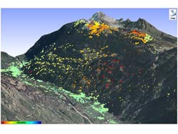
The Permanent Scatterers Technique (PS), developed and patented in the year 1999 at POLIMI, allows measuring with millimeter accuracy the ground deformation of single radar coherent and persistent reference points on wide areas. Precursors of land-sliding phenomena have been identified by means of such a technique. Moreover, the motion of single buildings has been monitored in urban areas by means of the PS technique.