
Céline Dizerens, Fabia Hüsler, & Stefan Wunderle
Institute of Geography and Oeschger Centre for Climate Change Research, University of Bern, Hallerstrasse 12, CH-3012 Bern
Politecnico di Milano - Como Campus, Meeting Room (third floor, Via Anzani 42, Como)
February 16th, 2016
10.00 am
Contact:
Roman Fedorov
Research Line:
Data, web, and society
Abstract
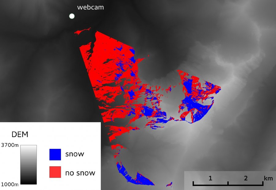
Georectification and snow classification of webcam images: potential for complementing satellite-derrived snow maps over SwitzerlandThe spatial and temporal variability of snow cover has a significant impact on climate and environment and is of great socio-economic importance for the European Alps. Satellite remote sensing data is widely used to study snow cover variability and can provide spatially comprehensive information on snow cover extent. However, cloud cover strongly impedes the surface view and hence limits the number of useful snow observations.
Outdoor webcam images not only offer unique potential for complementing satellite-derived snow retrieval under cloudy conditions but could also serve as a reference for improved validation of satellite-based approaches. Thousands of webcams are currently connected to the Internet and deliver freely available images with high temporal and spatial resolutions. To exploit the untapped potential of these webcams, a semi-automatic procedure was developed to generate snow cover maps based on webcam images. We used daily webcam images of the Swiss alpine region to apply, improve, and extend existing approaches dealing with the positioning of photographs within a terrain model, appropriate georectification, and the automatic snow classification of such photographs.
In this presentation, I will provide an overview of the implemented procedure and demonstrate how our registration approach automatically resolves the orientation of a webcam by using a high-resolution digital elevation model and the webcam’s position. This allows snow-classified pixels of webcam images to be related to their real-world coordinates. The resulting snow cover maps have the same resolution as the digital elevation model and indicate whether each grid cell is snow-covered, snowfree, or not visible from webcams’ positions. The procedure is expected to work under almost any weather condition and demonstrates the feasibility of using webcams for the retrieval of high-resolution snow cover information.