ICT & Remote Sensing for large scale monitoring of fluvial systems
The HydroInformatics Lab seminars
Simone Bizzi, Ph.D.
European Commission, JRC, IES, Water Resources Unit, Ispra, Italy
DEIB – Seminar Room
March 30th, 2016
10.30 am
Contact:
Andrea Castelletti
Research Line:
Planning and management of environmental systems
Simone Bizzi, Ph.D.
European Commission, JRC, IES, Water Resources Unit, Ispra, Italy
DEIB – Seminar Room
March 30th, 2016
10.30 am
Contact:
Andrea Castelletti
Research Line:
Planning and management of environmental systems
Sommario
Remote Sensing (RS) technologies over the last decade have made substantial progresses in terms of data accuracy, spatial coverage and temporal frequency of acquisitions. A valuable amount of information to investigate river systems has begun to emerge, which was not available in the past. RS data poses a number of data analysis challenges, which call for multi-disciplinary working groups where river experts work side by side with remote sensing experts and data analysts.
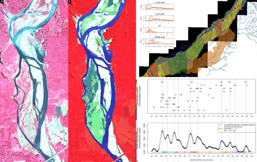
In this work, we use a regional available dataset in the Piedmont region (north east of Italy) acquired in 2008 including high-resolution multi-spectral images and LiDAR data to generate through semi-automated classification procedures a regional database of river geomorphic features. We have been able to detect meaningful rela tionships between geomorphic drivers (e.g. channel gradient, basin area, geology, geographic area), human pressures and channel features providing robust basis to generate a firsts assessments of river system alterations induced by human activities at regional level, and generating valuable evidences to discuss the design of more effective river management plans and rehabilitation measures. The developed ICT tools can be easily applied in the future in other contexts with simila r data availability. That is of notable interest for the upcoming generation of data acquired by Sentinel satellites. Such amount of newly generated data is shifting the limiting factor for river science from data generation to data processing. Findings and tools developed for this work will be used as an exploratory example for a discussion on potentialities and challenges in the future of fluvial systems monitoring.
In this work, we use a regional available dataset in the Piedmont region (north east of Italy) acquired in 2008 including high-resolution multi-spectral images and LiDAR data to generate through semi-automated classification procedures a regional database of river geomorphic features. We have been able to detect meaningful rela tionships between geomorphic drivers (e.g. channel gradient, basin area, geology, geographic area), human pressures and channel features providing robust basis to generate a firsts assessments of river system alterations induced by human activities at regional level, and generating valuable evidences to discuss the design of more effective river management plans and rehabilitation measures. The developed ICT tools can be easily applied in the future in other contexts with simila r data availability. That is of notable interest for the upcoming generation of data acquired by Sentinel satellites. Such amount of newly generated data is shifting the limiting factor for river science from data generation to data processing. Findings and tools developed for this work will be used as an exploratory example for a discussion on potentialities and challenges in the future of fluvial systems monitoring.
Biografia
Simone Bizzi research’s interest concerns the developing of modelling frameworks to describe and predict fluvial geomorphic behaviours and to investigate links between river hydromorphology and ecology. He obtained his PhD degree at University of Sheffield Department of Civil and Structural Engineering, Catchment Science Centre. Presently he is PostDoc grant-holder at Joint Research Centre of European Commission, Institute for Environment and Sustainability,Water Resource Unit and hi s research has focused on the use of remote sensing technology for characterizing, understanding and modelling fluvial systems.